
3 Chapter 3 Planet earth and Plate tectonics for print only
Earth is a terrestrial planet in the solar system, and it is very much like the other inner planets, at least in its size, shape, and composition. However, many features make Earth very different from the planets and any other planet that we know of so far.
Earth is a sphere or, more correctly, an oblate spheroid, which is a sphere that is a bit squished down at the poles and bulges a bit at the equator. Alternatively, to be more technical, the minor axis (the diameter through the poles) is smaller than the major axis (the diameter through the equator). When the earth is cut into equal halves, each half is called a hemisphere. North of the equator is the northern hemisphere and south of the equator is the southern hemisphere. Eastern and western hemispheres are also designated.
Even the ancient Greeks knew that Earth was round by observing the arc shape of the shadow on the Moon during a lunar eclipse. The Sun and the other planets of the solar system are also spherical. Larger satellites, those that have enough mass for their gravitational attraction to have made them round, are as well.
Earth has a magnetic field that behaves as if the planet had a gigantic bar magnet inside of it. Earth’s magnetic field also has a north and south pole and a magnetic field that surrounds it. The magnetic field arises from the convection of molten iron and nickel metal in Earth’s outer liquid iron core. Earth’s magnetic field extends several thousand kilometers into space. The magnetic field shields the planet from harmful radiation from the Sun.

3.1 Earth’s Rotation and revolution
Imagine a line passing through the center of Earth that goes through both the North Pole and the South Pole. This imaginary line is called an axis. Earth spins around its axis, just as a top spins around its spindle. This spinning movement is called Earth’s rotation. At the same time that the Earth spins on its axis, it also orbits or revolves around the Sun, called a revolution.
A pendulum set in motion will not change its motion, and so the direction of its swinging should not change. However, Foucault observed that his pendulum did seem to change direction. Since he knew that the pendulum could not change its motion, he concluded that the Earth, underneath the pendulum was moving. An observer in space will see that Earth requires 23 hours, 56 minutes, and 4 seconds to make one complete rotation on its axis. However, because Earth moves around the Sun at the same time that it is rotating, the planet must turn just a little bit more to reach the same place relative to the Sun. Hence the length of a day on Earth is 24 hours. At the equator, the Earth rotates at a speed of about 1,700 km per hour, but at the poles, the movement speed is nearly nothing.

For Earth to make one complete revolution around the Sun takes 365.24 days. This amount of time is the definition of one year. The gravitational pull of the Sun keeps Earth and the other planets in orbit around the star. Like the other planets, Earth’s orbital path is an ellipse, so the planet is sometimes farther away from the Sun than at other times. The closest Earth gets to the Sun each year is at perihelion (147 million km) on about January 3rd, and the furthest is at aphelion (152 million km) on July 4th. Earth’s elliptical orbit has nothing to do with Earth’s seasons.
During one revolution around the Sun, Earth travels at an average distance of about 150 million km. Earth revolves around the Sun at an average speed of about 27 km (17 mi) per second, but the speed is not constant. The planet moves slower when it is at aphelion and faster when it is at perihelion.
The reason the Earth has seasons is that Earth is tilted 23.5 degrees on its axis. During the Northern Hemisphere summer the North Pole points toward the Sun, and in the Northern Hemisphere winter, the North Pole has tilted away from the Sun.
3.2 Geologic Time
In 1788, after many years of geological study, James Hutton, one of the early pioneers of geology, wrote the following about the age of the Earth: “The result, therefore, of our present inquiry is, that we find no vestige of a beginning, — no prospect of an end.” Although he was not precisely correct (there was a beginning, and there will be an end to planet Earth), he was trying to express the vastness of geological time that humans have a hard time perceiving. Although Hutton did not assign an age to the Earth, he was the first to suggest that the planet was very old. Today we know Earth is approximately 4.54 ± 0.05 billion years old, an age first calculated by Caltech professor Clair Patterson in 1956 by radiometrically dating meteorites with uranium-lead dating.
On a geologic scale, the lifespan of a human is very short, and we struggle to comprehend the depth of geologic time and slow geologic processes. Studying geologic time, also known as deep time, can help us overcome our limited view of Earth during our lifetime. For example, the science of earthquakes only goes back about 100 years; however, geologic evidence shows that large earthquakes have occurred in the past and will continue to occur in the future. Thus, human perspective of time does not always overlap with geologic timescales.
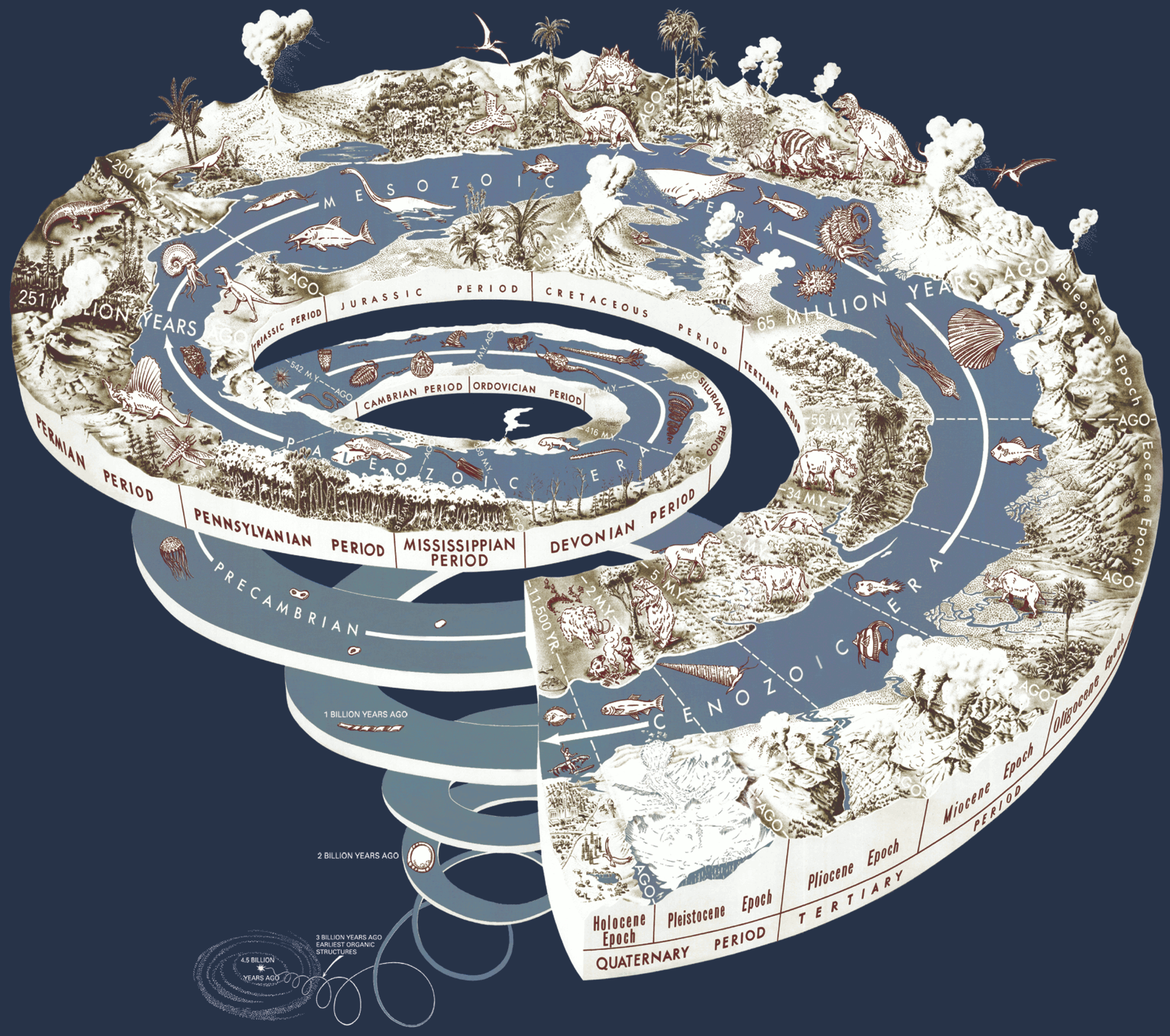
A diagram of the geological time scale.The largest division of time is the Eon—Hadean, Archean, Proterozoic (sometimes combined together as the Precambrian), and Phanerozoic. Although life appeared more than 3,800 million of years ago (Ma), during most of Earth history from 3,500 Ma to 542 Ma (88 percent of geologic time), life forms consisted mainly of simple single-celled organisms such as bacteria. Only in more recent geologic time have more biologically complex organisms appeared in the geologic record.
3.3. Structure of the Earth
The fundamental unifying principle of geology and the rock cycle is the Theory of Plate Tectonics. Plate tectonics describes how the layers of the Earth move relative to each other. Specifically, the outer layer divided into tectonic or lithospheric plates. As the tectonic plates float on a mobile layer beneath called the asthenosphere, they collide, slide past each other, and split apart. At these plate boundaries, significant landforms are created, and rocks comprising the tectonic plates move through the rock cycle.
The following is a summary of the Earth’s layers based on chemical composition (or the chemical makeup of the layers). Earth has three main geological layers based on chemical composition – crust, mantle, and core. The outermost layer is the crust and is composed of mostly silicon, oxygen, aluminum, iron, and magnesium. There are two types of crust, continental and oceanic crust. Continental crust. is about 50 kilometers (30 miles) thick, represents most of the continents, and is composed of low-density igneous and sedimentary rocks. Oceanic crust is approximately 10 kilometers (6 miles) thick, makes up most of the ocean floor, and covers about 70 percent of the planet. Oceanic crust is high-density igneous basalt-type rocks. The moving tectonic plates are made of crust, and some of the next layers within the earth called the mantle. The crust and this portion of the upper mantle are rigid and called the lithosphere and comprise the tectonic plates.
Continents
The oldest continental rocks are billions of years old, so the continents have had a lot of time for things to happen to them. Constructive forces cause physical features on Earth’s surface known as landforms to grow. Crustal deformation – when crust compresses, pulls apart, or slides past other crust – results in hills, valleys, and other landforms. Mountains rise when continents collide, when one slab of ocean crust plunges beneath another or a slab of continental crust to create a chain of volcanoes. Sediments are deposited to form landforms, such as deltas.
Volcanic eruptions can also be destructive forces that blow landforms apart. The destructive forces of weathering and erosion modify landforms. Water, wind, ice, and gravity are important forces of erosion.
Oceanic Basins
The ocean basins are all younger than 180 million years. Although the ocean basins begin where the ocean meets the land, the continent extends downward to the seafloor, so the continental margin is made of continental crust.
The ocean floor itself is not totally flat. The most distinctive feature is the mountain range that runs through much of the ocean basin, known as the mid-ocean ridge. The deepest places of the ocean are the ocean trenches, many of which are located around the edge of the Pacific Ocean. Chains of volcanoes are also found in the center of the oceans, such as in the area of Hawaii. Flat plains are found on the ocean floor with their features covered by mud.

The mantle is below the crust and is the most significant layer by volume, extending down to about 2,900 km (1,800 miles). The mantle is mostly solid and made of peridotite, a high-density rock composed of silica, iron, and magnesium. The upper part of this solid material is so hot that it is flexible and allows the tectonic plates floating on it to move relative to each other. Under the mantle is the 3,500 km (2,200 mi) thick core made of iron and nickel. The outer core is liquid, and the inner core is solid. Rotations within the solid and liquid metallic core generate Earth’s magnetic field.

3.4 Rocks
A rock is a naturally formed, non-living earth material composed of one or more minerals or mineraloids (Typically, substances like coal, pearl, opal, or obsidian that do not fit the definition of a mineral are called mineraloids.). The mineral grains in a rock may be so tiny that they can only see them with a microscope, or several centimeters in size.
There are three main types of rocks composed of minerals: igneous (rocks crystallizing from molten material), sedimentary (rocks composed of products of mechanical weathering (sand, gravel, etc.) and chemical weathering (things precipitated from solution), and metamorphic (rocks produced by alteration of other rocks by heat and pressure. Click here to learn more about rocks and minerals from the Utah Geologic Survey.
What is a Mineral?
Minerals are categorized based on their chemical composition. Owing to similarities in composition, minerals within the same group may have similar characteristics. Geologists have a precise definition of minerals. A material is characterized as a mineral if it meets all of the following traits:
- Inorganic, crystalline solid.
- Formed through natural processes and has a definite chemical composition.
- Identified by their characteristic physical properties such as crystalline structure, hardness, density, flammability, and color.
Crystalline Solid
Minerals are crystalline solids. A crystal is a solid in which the atoms are arranged in a regular, repeating pattern. The pattern of atoms in different samples of the same mineral is the same. Is glass a mineral? Without a crystalline structure, even natural glass is not a mineral.
Inorganic Substances
Organic substances are the carbon-based compounds made by living creatures and include proteins, carbohydrates, and oils. Inorganic substances have a structure that is not characteristic of living bodies. Coal is made of plant and animal remains. Is it a mineral? Coal is a classified as a sedimentary rock but is not a mineral.
Natural Processes
Minerals are made by natural processes, those that occur in or on Earth. A diamond created deep in Earth’s crust is a mineral. Is a diamond created in a laboratory by placing carbon under high pressures a mineral? No. Do not buy a laboratory-made “diamond” for jewelry without realizing it is not technically a mineral. But also be careful you do not purchase blood diamonds or other minerals that were mined to fund war, mass murders, or genocides.
Chemical Composition
Nearly all (98.5 percent) of Earth’s crust is made up of only eight elements – oxygen, silicon, aluminum, iron, calcium, sodium, potassium, and magnesium – and these are the elements that make up most minerals.
All minerals have a specific chemical composition. The mineral silver is made up of only silver atoms and diamond is made only of carbon atoms, but most minerals are made up of chemical compounds. Each mineral has its own chemical formula. Halite is NaCl (sodium chloride). Quartz is always made of two oxygen atoms bonded to a silicon atom, SiO2. If a mineral contains any other elements in its crystal structure, it is not quartz.
A hard mineral containing covalently bonded carbon is diamond, but a softer mineral that also contains calcium and oxygen along with carbon is calcite. Some minerals have a range of chemical composition. Olivine always has silicon and oxygen as well as iron or magnesium or both.
Finding and Mining Minerals
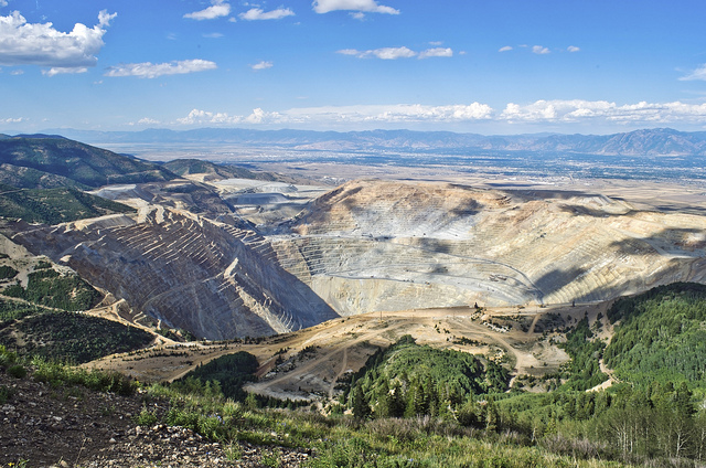
Geologic processes create and concentrate minerals that are valuable natural resources. Geologists study geological formations and then test the physical and chemical properties of soil and rocks to locate possible ores and determine their size and concentration. A mineral deposit will only be mined if it is profitable. A concentration of minerals is only called an ore deposit if it is profitable to mine. There are many ways to mine ores.
Surface mining allows extraction of ores that are close to Earth’s surface. Overlying rock is blasted, and the rock that contains the valuable minerals is placed in a truck and taken to a refinery. Surface mining includes open-pit mining and mountaintop removal. Other methods of surface mining include strip mining, placer mining, and dredging. Strip mining is like open pit mining but with material removed along a strip.
Placers are valuable minerals found in stream gravels. California’s nickname, the Golden State, can be traced back to the discovery of placer deposits of gold in 1848. The gold weathered out of hard metamorphic rock in the western Sierra Nevada, which also contains deposits of copper, lead, zinc, silver, chromite, and other valuable minerals. The gold traveled down rivers and then settled in gravel deposits. Currently, California has active mines for gold and silver and for non-metal minerals such as sand and gravel, which are used for construction.
Underground mining is used to recover ores that are deeper into Earth’s surface. Miners blast and tunnel into rock to gain access to the ores. How underground mining is approached – from above, below, or sideways – depends on the placement of the ore body, its depth, concentration of ore, and the strength of the surrounding rock. Underground mining is costly and dangerous. Fresh air and lights must also be brought into the tunnels for the miners, and accidents are far too frequent.
The ore’s journey to becoming a useable material is only just beginning when the ore leaves the mine. Rocks are crushed so that the valuable minerals can be separated from the waste rock. Then the minerals are separated out of the ore. To extract the metal from the ore, the rock is melted at a temperature greater than 900°C, which requires much energy. Extracting metal from rock is so energy intensive that if you recycle just 40 aluminum cans, you will save the energy equivalent of one gallon of gasoline.
Although mining provides people with many necessary resources, the environmental costs can be high. Surface mining clears the landscape of trees and soil, and nearby streams and lakes are inundated with sediment. Pollutants from the mined rock, such as heavy metals, enter the sediment and water system. Acids flow from some mine sites, changing the composition of nearby waterways.
U.S. law has changed so that in recent decades a mine region must be restored to its natural state, a process called reclamation. This is not true of older mines. Pits may be refilled or reshaped and vegetation planted. Pits may be allowed to fill with water and become lakes or may be turned into landfills. Underground mines may be sealed off or left open as homes for bats.
Some minerals are valuable because they are beautiful. Jade has been used for thousands of years in China. Diamonds sparkle on many engagement rings. Minerals like jade, turquoise, diamonds, and emeralds are gemstones. A gemstone, or gem, is a material that is cut and polished for jewelry. Gemstones are usually rare and do not break or scratch easily. Most are cut along cleavage faces and then polished so that light bounces back off the cleavage planes. Light does not pass through gemstones that are opaque, such as turquoise. Gemstones are not just used in jewelry. Diamonds are used to cut and polish other materials, such as glass and metals, because they are so hard. The mineral corundum, of which ruby and sapphire are varieties, is used in products such as sandpaper.
Minerals are used in much less obvious places. The mineral gypsum is used for the sheetrock in homes. Window glass is made from sand, which is mostly quartz. Halite is mined for rock salt. Copper is used in electrical wiring, and bauxite is the source for the aluminum used in soda cans.
3.5 The Rock Cycle
The most fundamental view of Earth materials is the rock cycle, which presents the primary materials that comprise the Earth and describes the processes by which they form and relate to each other. The rock cycle is usually said to begin with a hot molten liquid rock called magma or lava. Magma forms under the Earth’s surface in the crust or mantle and erupts on Earth’s surface as lava. When magma or lava cools, it solidifies by a process called crystallization in which minerals grow within the magma or lava. The rock that results from this is an igneous rock from the Latin word ignis, meaning “fire.”
Igneous rocks, as well as other types of rocks, on Earth’s surface, are exposed to processes of weathering and erosion to produce sediments. Weathering is the physical and chemical breakdown of rocks into smaller fragments and erosion is the removal of those fragments from their original location. Once igneous rocks are broken down and transported, these fragments or grains are considered sediments. Sediments such as gravel, sand, silt, and clay can be transported by water in the form of streams, ice in the form of glaciers, and air in the form of wind. Sediments ultimately come to rest in a process known as deposition. The deposited sediments accumulate in place, often under water such as a shallow marine environment, get buried.
Within the burial process, the sediments go through compaction by the weight of overlying sediments and cementation as minerals in groundwater glue the sediments together. The process of compacting and cementing sediments together is lithification, and lithified sediments are considered a sedimentary rock, such as sandstone and shale. Other sedimentary rocks, known as chemical sedimentary rocks, are not made of weathered and eroded sedimentary fragments. They are instead made by direct chemical precipitation of minerals.
Pre-existing rocks may be metamorphosed into a metamorphic rock, meta- means “change”, -morphos means “form” or “shape.” When rocks are subjected to extreme increases in temperatures or pressures, the minerals alter into enlarged crystals, or entirely new minerals with similar chemical make up. These high temperatures and pressures can occur when rocks are buried deep within the Earth’s crust or where they come into contact with hot magma or lava. In some cases, the temperature and pressure conditions can allow rocks to melt and create magma and lava, thus showing the cyclical nature of the rock cycle as new rocks are born.
Click here to learn more about various types of igneous, sedimentary, and metamorphic rocks from the Utah Geologic Survey (UGS).

3.6 Igneous Rocks
Igneous rocks form from the cooling and hardening of molten magma in many different environments. These rocks are identified by their composition and texture. More than 700 different types of igneous rocks are known.
Magma Composition
The rock beneath the Earth’s surface is sometimes heated to high enough temperatures that it melts to create magma. Different magmas have different composition and contain whatever elements were in the rock that melted. Magmas also contain gases. The main elements are the same as the elements found in the crust. Whether rock melts to create magma depends on:
- Temperature: Temperature increases with depth, so melting is more likely to occur at greater depths.
- Pressure: Pressure increases with depth, but increased pressure raises the melting temperature, so melting is less likely to occur at higher pressures.
- Water: The addition of water changes the melting point of rock. As the number of water increases, the melting point decreases.
- Rock composition: Minerals melt at different temperatures, so the temperature must be high enough to melt at least some minerals in the rock. The first mineral to melt from a rock will be quartz (if present), and the last will be olivine (if present).
As a rock heats up, the minerals that melt at the lowest temperatures will melt first. Partial melting occurs when the temperature on a rock is high enough to melt only some of the minerals in the rock. The minerals that will melt will be those that melt at lower temperatures. Fractional crystallization is the opposite of partial melting. This process describes the crystallization of different minerals as magma cools.
If the liquid separates from the solids at any time in partial melting or fractional crystallization, the chemical composition of the liquid and solid will be different. When that liquid crystallizes, the resulting igneous rock will have a different composition from the parent rock.
Intrusive Igneous Rock
Igneous rocks are called intrusive when they cool and solidify beneath the surface. When magma cools within the Earth, the cooling proceeds slowly. Intrusive igneous rocks cool slower than extrusive igneous rocks, which allows for larger crystal structure to take develop.
Igneous rocks make up most of the rocks on Earth. Most igneous rocks are buried below the surface and covered with sedimentary rock, or are buried beneath the ocean water. In some places, geological processes have brought igneous rocks to the surface. Yosemite is a classic example of intrusive igneous rock. The molten magma never reached Earth’s surface, so the molten material had millions of years to cool down slowly to form granite. Later, geologic forces and erosion have caused those granite plutons to surface as they are today.
Extrusive Igneous Rock
Igneous rocks are called extrusive when they cool and solidify above the surface. These rocks usually form from a volcano, so they are also called volcanic rocks. Extrusive igneous rocks cool much more rapidly than intrusive rocks, reducing the time for crystal structure to form within the rocks.
Cooling rate and gas content create a variety of rock textures. Lavas that cool exceptionally rapidly may have a glassy texture. Those with many holes from gas bubbles have a vesicular texture.
Human Uses of Igneous Rock
Igneous rocks have a wide variety of uses. One significant use is as stone for buildings and statues. Granite is used for both of these purposes and is popular for kitchen countertops. Pumice is commonly used as an abrasive as household products or for smoothing skin. Ground up pumice stone is sometimes added to toothpaste to act as an abrasive material to scrub teeth. Peridotite is sometimes mined for peridot, a type of olivine that is used in jewelry. Diorite was used extensively by ancient civilizations for vases and other decorative artwork and is still used for art today.
3.7 Sedimentary Rock
Sandstone is one of the common types of sedimentary rocks that form from sediments. There are many other types. Sediments may include:
- Fragments of other rocks that often have been worn down into small pieces, such as sand, silt, or clay.
- Organic materials, or the remains of once-living organisms
- Chemical precipitates, which are materials that get left behind after the water evaporates from a solution.
Rocks at the surface undergo mechanical and chemical weathering. These physical and chemical processes break rock into smaller pieces. Physical weathering breaks the rocks apart, whereas chemical weathering dissolves the less stable minerals. These original elements of the minerals end up in solution, and new minerals may form. Sediments are removed and transported by water, wind, ice, or gravity in a process called erosion.
Streams carry vast amounts of sediment. The more energy the water has, the larger the particle it can carry. A rushing river on a steep slope might be able to carry boulders. As this stream slows down, it no longer has the energy to carry large sediments and will drop them. A slower moving stream will only carry smaller particles.
Sediments are deposited on beaches and deserts, at the bottom of oceans, and in lakes, ponds, rivers, marshes, and swamps. Avalanches drop large piles of sediment. Glaciers leave large piles of sediments, too. Wind can only transport sand and smaller particles. The type of sediment that is deposited will determine the type of sedimentary rock that can form. Different colors of sedimentary rock are determined by the environment where they are deposited. Red rocks form where oxygen is present, whereas darker sediments form when the environment is oxygen-poor.
Sedimentary Rock Formation
Accumulated sediments harden into rock by a process called lithification. Two important steps are needed for sediments to lithify.
Sediments are squeezed together by the weight of overlying sediments on top of them, called compaction. Cemented, non-organic sediments become clastic rocks. If organic material is included, they are bioclastic rocks.
Fluids fill in the spaces between the loose particles of sediment and crystallize to create a rock by cementation. When sediments settle out of calmer water, they form horizontal layers. One layer is deposited first, and another layer is deposited on top of it. So each layer is younger than the layer beneath it. When the sediments harden, the layers are preserved. Sedimentary rocks formed by the crystallization of chemical precipitates are called chemical sedimentary rocks.
Biochemical sedimentary rocks form in the ocean or a salt lake. Living creatures remove ions, such as calcium, magnesium, and potassium, from the water to make shells or soft tissue. When the organism dies, it sinks to the ocean floor to become biochemical sediment, which may then become compacted and cemented into solid rock.

Human Use of Sedimentary Rock
Sedimentary rocks are used as building stones, although they are not as hard as igneous or metamorphic rocks. Sedimentary rocks are used in construction. Sand and gravel are used to make concrete; they are also used in asphalt. Many economically valuable resources come from sedimentary rocks. Iron ore and aluminum are two examples.
3.8 Metamorphic Rock
Metamorphism is the addition of heat and/or pressure to existing rocks, which causes them to change physically and/or chemically so that they become a new rock. Metamorphic rocks may change so much that they may not resemble the original rock.
Any type of rock – igneous, sedimentary, or metamorphic – can become a metamorphic rock. All that is needed is enough heat and/or pressure to alter the existing rock’s physical or chemical makeup without melting the rock entirely. Rocks change during metamorphism because the minerals need to be stable under the new temperature and pressure conditions. The need for stability may cause the structure of minerals to rearrange and form new minerals. Ions may move between minerals to create minerals of the different chemical composition. Hornfels, with its alternating bands of dark and light crystals, is an excellent example of how minerals rearrange themselves during metamorphism.
Extreme pressure may also lead to foliation, the flat layers that form in rocks as pressure squeezes the rocks. Foliation forms typically when pressure is exerted in only one direction. Metamorphic rocks may also be non-foliated. Quartzite and limestone are nonfoliated. The two main types of metamorphism are both related to heat within Earth:
- Regional metamorphism: Changes in enormous quantities of rock over a wide area caused by the extreme pressure from overlying rock or compression caused by geologic processes. Deep burial exposes the rock to high temperatures.
- Contact metamorphism: Changes in a rock that is in contact with magma because of the magma’s extreme heat.
Quartzite is very hard and is often crushed and used in building railroad tracks. Schist and slate are sometimes used as building and landscape materials. Graphite, the “lead” in pencils, is a mineral commonly found in metamorphic rocks.
The Utah Geologic Survey has several resources related to landforms in Utah. They have also created a fun story map called GeoSights of popular geologic sights within the State of Utah.
Plate tectonics
Revolution is a word usually reserved for significant political or social changes. In science, there have been several revolutions of ideas (paradigm shifts) that have forced scientists to re-examine their entire field. Darwin’s On the Origin of Species in 1859, Mendel’s discovery of genetics in 1866, and the discovery of DNA by James Watson, Francis Crick, and Rosalind Franklin in the 1950s did that for biology. Albert Einstein’s relativity and quantum mechanics concepts in the early twentieth century did the same for Newtonian physics. Plate tectonics was just as revolutionary for geology. Plate tectonics, the idea that the outer part of the Earth moves and causes earthquakes, mountains, and volcanoes, is the lens through which geologic study must be viewed because all earth processes make more sense in this context. Its importance in understanding how the world works is why it is the first topic of discussion in this text.
3.9 Continental Drift Hypothesis
Alfred Wegener (1880-1930) was a German scientist who specialized in meteorology and climatology. He had a knack for questioning accepted ideas, and this started in 1910 when he disagreed with isostasy (vertical land movement due to the weight being removed or added) as the explanation for the Bering Land Bridge. After literary reviews, he published a hypothesis stating the continents had moved in the past. While he did not have the precise mechanism worked out, he had a long list of evidence that backed up his hypothesis of continental drift.
Early Evidence for Continental Drift
The first piece of evidence is that the shape of the coastlines of some continents fit together like pieces of a jigsaw puzzle. Since the first world map, people have noticed the similarities in the coastlines of South America and Africa, and the continents being ripped apart had even been mentioned as an explanation. Antonio Snider-Pellegrini even did preliminary work on continental separation and matching fossils in 1858.
What Wegener did differently than others was synthesized a significant amount of data in one place, as well as use the shape of the continental shelf, the actual edge of the continent, instead of the current coastline, which fit even better than previous efforts. Wegener also compiled and added to evidence of similar rocks, fossils, and glacial formations across the oceans.

Fossil Evidence
For example, the primitive aquatic reptile Mesosaurus was found on the separate coastlines of the continents of Africa and South America, and the reptile Lystrosaurus was found on Africa, India, and Antarctica. These were land-dwelling creatures that could not have swam across an entire ocean; thus this was explained away by opponents of continental drift by land bridges. The land bridges, which, in the hypothesis of proponents, had eroded away, allowed animals and plants to move between the continents. However, some of the presumed land bridges would have had to have stretched across broad, deep oceans.
Geologic Evidence
Mountain ranges with the same rock types, structures, and ages are now on opposite sides of the Atlantic Ocean. The Appalachians of the eastern United States and Canada, for example, are just like mountain ranges in eastern Greenland, Ireland, Great Britain, and Norway. Wegener concluded that they formed a single mountain range that was separated as the continents drifted.
Climatic Evidence
Another significant piece of evidence was climate anomalies. Late Paleozoic glacial evidence was found in widespread, warm areas like southern Africa, India, Australia, and the Arabian subcontinent. Wegener himself had found evidence of tropical plant fossils in areas north of the Arctic Circle. According to Wegener, the simpler explanation that fit all the climate, rock, and fossil observations, mainly as more data were collected, involved moving continents.
Grooves and rock deposits left by ancient glaciers are found today on different continents very close to the equator. This would indicate that the glaciers either formed in the middle of the ocean and/or covered most of the Earth. Today glaciers only form on land and nearer the poles. Wegener thought that the glaciers were centered over the southern land mass close to the South Pole and the continents moved to their present positions later on.

Proposed Mechanism for Continental Drift
Wegener’s work was considered a fringe theory for his entire life. One of the most significant apparent flaws and easiest dismissals of Wegener’s hypothesis was a mechanism for movement of the continents. The continents did not appear to move, and extraordinary evidence would need to be provided to change the minds of the establishment, including a mechanism for movement. Other pro-continental drift followers had used expansion, contraction, or even the origin of the Moon as ideas to how the continents moved. Wegener used centrifugal forces and precession to explain the movement, but that was proven wrong. He had some speculation about seafloor spreading, with hints of convection within the earth, but these were unsubstantiated. As it turns out, convection within the mantle has been revealed as a significant force in driving plate movements, according to current knowledge.
3.10 Development of the Theory of Plate Tectonics
Wegener died in 1930 on an expedition in Greenland. In his lifetime, he was poorly respected, and his ideas of moving continents seemed destined to be lost to history as a fringe idea. However, starting in the 1950s, evidence started to trickle in that made continental drift more viable. By the 1960’s, there was enough evidence supporting Wegener’s missing mechanism, seafloor spreading, allowing the hypothesis of continental drift to develop into the Theory of Plate Tectonics. Widespread acceptance among scientists has transformed Wegener’s hypothesis to a Theory. Today, GPS and earthquake data continue to back up the theory. Below are the pieces of evidence that allowed the transformation.
Mapping the Ocean Floors
Starting in 1947 and using an adaptation of SONAR, researchers began to map a poorly-understood topographic, and thermal high in the mid-Atlantic . Bruce Heezen and Marie Tharp were the first to make a detailed map of the ocean floor, and this map revealed the mid-Atlantic Ridge, a basaltic feature, unlike the continents. Initially, this was thought to be part of an expanding Earth or a mechanism for the growth of the ocean. Transform faults were also added to explain movements more completely. When it was later realized that earthquake epicenters were also located within this feature, the idea that this was part of continental movement took hold.
Another way the seafloor was mapped was magnetically. Scientists had long known of strange magnetic anomalies (magnetic values that differ from expected values) associated with the ocean floor. This tool was adapted by geologists later for further study of the ocean depths, including strange alternating symmetrical stripes on both sides of a feature (which would be discovered later as the mid-ocean ridge) showing reversing magnetic pole directions. By 1963, these magnetic stripes would be explained in concordance with the spreading model of Hess and others.
Seafloor sediment was also an important feature that was measured in the oceans, both with dredging and with drilling. Sediment was believed to have been piling up on ocean floors for a very long time in a static model of accumulation. Initial studies showed less sediment than expected, and initial results were even used to argue against continental movement. With more time, researchers discovered thinner sediment close to ridges, indicating a younger age.
As the video below explains, today scientists are also able to use satellite imagery to map the ocean floor.
Seafloor Spreading Hypothesis
World War II gave scientists the tools to find the mechanism for continental drift that had eluded Wegener. Maps and other data gathered during the war allowed scientists to develop the seafloor spreading hypothesis. This hypothesis traces oceanic crust from its origin at a mid-ocean ridge to its destruction at a deep sea trench and is the mechanism for continental drift.
During World War II, battleships and submarines carried echo sounders to locate enemy submarines. Echo sounders produce sound waves that travel outward in all directions, bounce off the nearest object, and then return to the ship. By knowing the speed of sound in seawater, scientists calculate the distance to the object based on the time it takes for the wave to make a round-trip. During the war, most of the sound waves ricocheted off the ocean bottom. This animation shows how sound waves are used to create pictures of the seafloor and ocean crust.
After the war, scientists pieced together the ocean depths to produce bathymetric maps, which reveal the features of the ocean floor as if the water were taken away. Even scientists were amazed that the seafloor was not completely flat. What was discovered was a large chain of mountains along the deep seafloor, called mid-ocean ridges. Scientists also discovered deep-sea trenches along the edges of continents or in the sea near chains of active volcanoes. Finally, large, flat areas called abyssal plains we found. When they first observed these bathymetric maps, scientists wondered what had formed these features.
Scientists brought these observations together in the early 1960s to create the seafloor spreading hypothesis. In this hypothesis, hot buoyant mantle rises up a mid-ocean ridge, causing the ridge to rise upward. The hot magma at the ridge erupts as lava that forms new seafloor. When the lava cools, the magnetite crystals take on the current magnetic polarity and as more lava erupts, it pushes the seafloor horizontally away from ridge axis.
The magnetic stripes continue across the seafloor. As oceanic crust forms and spreads, moving away from the ridge crest, it pushes the continent away from the ridge axis. If the oceanic crust reaches a deep sea trench, it sinks into the trench and is lost into the mantle. Scientists now know that the oldest crust is coldest and lies deepest in the ocean because it is less buoyant than the hot new crust.
The Unifying Theory of Plate Tectonics
Using all of the evidence mentioned, the theory of plate tectonics took shape. In 1966, J. Tuzo Wilson was the first scientist to put the entire picture together of an opening and closing ocean. Before long, models were proposed showing the plates moving concerning each other with clear boundaries between them, and scientists had also started to piece together complicated tectonic histories. The plate tectonic revolution had taken hold.
Seafloor and continents move around on Earth’s surface, but what is actually moving? What portion of the Earth makes up the “plates” in plate tectonics? This question was also answered because of technology developed during the Cold War. The tectonic plates are made up of the lithosphere. During the 1950s and early 1960s, scientists set up seismograph networks to see if enemy nations were testing atomic bombs. These seismographs also recorded all of the earthquakes around the planet. The seismic records could be used to locate an earthquake’s epicenter, the point on Earth’s surface directly above the place where the earthquake occurs. Earthquake epicenters outline these tectonic plates. Mid-ocean ridges, trenches, and large faults mark the edges of these plates along with where earthquakes occur.
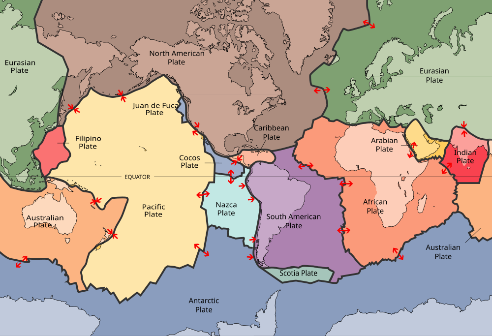
The lithosphere is divided into a dozen major and several minor tectonic plates. The plates’ edges can be drawn by connecting the dots that mark earthquakes’ epicenters. A single plate can be made of all oceanic lithosphere or all continental lithosphere, but nearly all plates are made of a combination of both. Movement of the plates over Earth’s surface is termed plate tectonics. Plates move at a rate of a few centimeters a year, about the same rate fingernails grow.
3.11 Layers of the Earth
To understand the details of plate tectonics, one must first understand the layers of the Earth. Humankind has insufficient first-hand information regarding what is below; most of what we know is pieced together from models, seismic waves, and assumptions based on meteorite material. In general, the Earth can be divided into layers based on chemical composition and physical characteristics.
Chemical Layers
The Earth has three main divisions based on their chemical composition, which means chemical makeup. Indeed, there are countless variations in composition throughout the Earth, but it appears that only two significant changes take place, leading to three distinct chemical layers.
Crust
The outermost chemical layer and the layer humans currently reside on is known as the crust. The crust has two types: continental crust, which is relatively low density and has a composition similar to granite, and oceanic crust, which is relatively high density (especially when it is cold and old) and has a composition similar to basalt. In the lower part of the crust, rocks start to be more ductile and less brittle, because of added heat. Earthquakes, therefore, generally occur in the upper crust.
At the base of the crust is a substantial change in seismic velocity called the Mohorovičić Discontinuity, or Moho for short, discovered by Andrija Mohorovičić (pronounced mo-ho-ro-vee-cheech) in 1909 by studying earthquake wave paths in his native Croatia. It is caused by the dramatic change in composition that occurs between the mantle and the crust. Underneath the oceans, the Moho is about 5 km down. Under continents, the average is about 30-40 km, except near a sizeable mountain-building event, known as an orogeny, where that thickness is about doubled.
Mantle
The mantle is the layer below the crust and above the core, and is the most substantial layer by volume, extending from the base of the crust to a depth of about 2900 km. Most of what we know about the mantle comes from seismic waves, though some direct information can be gathered from parts of the ocean floor that are brought to the surface, known as ophiolites. Also, carried within magma are xenoliths, which are small chunks of lower rock carried to the surface by eruptions. These xenoliths are mainly made of the rock peridotite, which on the scale of igneous rocks is ultramafic. We assume the majority of the mantle is made of peridotite.
Core
The core of the Earth, which has both liquid and solid components, is made mostly of iron and nickel and possibly minor oxygen. First discovered in 1906 by looking into seismic data, it took the union of modeling, astronomical insight, and seismic data to arrive at the idea that the core is mostly metallic iron. Meteorites contain much more iron than typical surface rocks, and if meteoric material is what made the Earth, the core would have formed as dense material (including iron and nickel) sank to the center of the Earth via its weight as the planet formed, heating the Earth intensely.
Physical Layers
The Earth can also be broken down into five distinct physical layers based on how each layer responds to stress. While there is some overlap in the chemical and physical designations of layers, specifically the core-mantle boundary, there are significant differences between the two systems.

Lithosphere
The lithosphere, with ‘litho’ meaning rock, is the outermost physical layer of the Earth. Including the crust, it has both an oceanic component and a continental component. Oceanic lithosphere, ranging from a thickness of zero (at the forming of new plates on the mid-ocean ridge) to 140 km, is thin and relatively rigid. Continental lithosphere is considerably more plastic in nature (especially with depth) and is overall thicker, from 40 to 280 km thick. Most importantly, the lithosphere is not continuous. It is broken into several segments that geologists call plates. A plate boundary is where two plates meet and move relative to each other. It is at and near plate boundaries where the real action of plate tectonics is seen, including mountain building, earthquakes, and volcanism.
Asthenosphere
The asthenosphere, with ‘astheno’ meaning weak, is the layer below the lithosphere. The most distinctive property of the asthenosphere is movement. While still solid, over geologic time scales it will flow and move because it is mechanically weak. It is in this layer that movement, partly driven by convection of intense interior heat, allows the lithospheric plates to move. Since certain types of seismic waves pass through the asthenosphere, we know that it is solid, at least at the very short time scales of the passage of seismic waves. The depth and occurrence of the asthenosphere are dependent on heat and can be very shallow at mid-ocean ridges and very deep in plate interiors and beneath mountains.
Mesosphere
The mesosphere, or lower mantle as it is sometimes called, is more rigid and immobile than the asthenosphere, though still hot. This can be attributed to increased pressure with depth. Between approximately 410 and 660 km depth, the mantle is in a state of transition as minerals with the same composition are changed to various forms, dictated by the conditions of increasing pressure. Changes in seismic velocity show this, and this zone also can be a physical barrier to movement. Below this zone, the mantle is relatively uniform and homogeneous, as no major changes occur until the core is reached.
The outer core is the only liquid layer found within Earth. It starts at 2,890 km (1,795 mi) depth and extends to 5,150 km (3,200 mi). Inge Lehmann, a Danish geophysicist, in 1936, was the first to prove that there was an inner core that was solid within the liquid outer core based on analyzing seismic data. The solid inner core is about 1,220 km (758 mi) thick, and the outer core is about 2,300 km (1,429 mi) thick.
It seems like a contradiction that the hottest part of the Earth is solid, as high temperatures usually lead to melting or boiling. The solid inner core can be explained by understanding that the immense pressure inhibits melting, though as the Earth cools by heat flowing outward, the inner core grows slightly larger over time. As the liquid iron and nickel in the outer core moves and convects, it becomes the most likely source for Earth’s magnetic field. This is critically important to maintaining the atmosphere and conditions on Earth that make it favorable to life. Loss of outer core convection and the Earth’s magnetic field could strip the atmosphere of most of the gases essential to life and dry out the planet; much like what has happened to Mars.
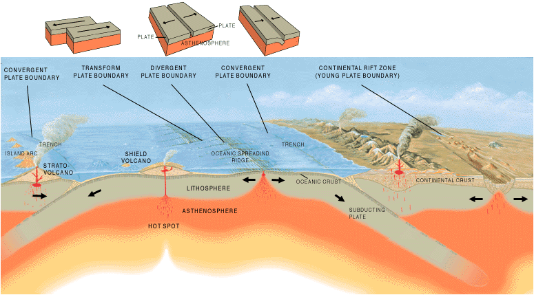
3.12 Plate Tectonic Boundaries
Places, where oceanic and continental lithospheric tectonic plates meet and move relative to each other, are called active margins (e.g., the western coasts of North and South America). A location where continental lithosphere transitions into oceanic lithosphere without movement is known as a passive margin (e.g., the eastern coasts of North and South America). This is why tectonic plates may be made of both oceanic and continental lithosphere. In the process of plate tectonics, the lithospheric plates movement is the primary force that causes the majority of features and activity on the Earth’s surface that can be attributed to plate tectonics. This movement occurs (at least partially) via the drag of motion within the asthenosphere and because of density.
As they move, the tectonic plates interact with each other at the boundaries between the tectonic plates. These interactions are the primary drivers of mountain building, earthquakes, and volcanism on the planet. In a simplified plate tectonic model, plate interaction can be placed in one of three categories. In places where plates move toward each other, the boundary is known as convergent. In places where plates move apart, the boundary is known as divergent. In places where the plates slide past each other, the boundary is known as a transform boundary. The next three subchapters will explain the details of the movement at each type of boundary.
Convergent Boundaries
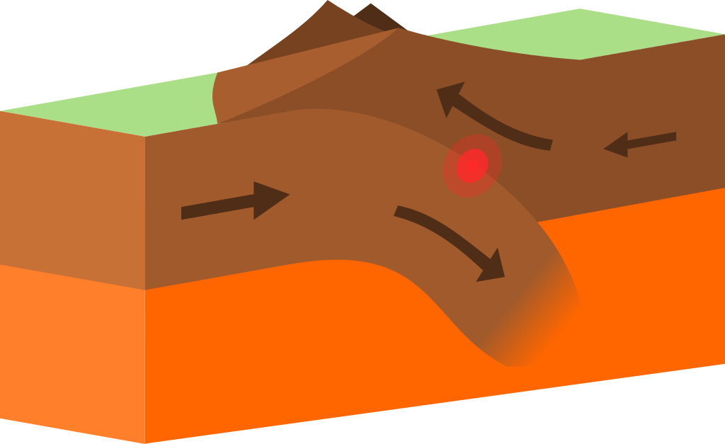
Convergent boundaries, sometimes called destructive boundaries, are places where two or more tectonic plates have a net movement toward each other. The key to convergent boundaries is understanding the density of each plate involved in the movement. Continental lithosphere is always lower in density and is buoyant when compared to the asthenosphere. Oceanic lithosphere, on the other hand, is denser than continental lithosphere and, when old and cold, may even be denser than the asthenosphere. When plates of different density converge, the more dense plate sinks beneath, the less dense plate, a process called subduction.

Subduction is when oceanic lithosphere descends into the mantle due to its density. The average rate of subduction of oceanic crust worldwide is 25 miles per million years, about a half inch per year. Continental lithosphere can partially subduct if attached to sinking oceanic lithosphere, but its buoyancy does not allow it to subduct fully. As the tectonic plate descends, it also pulls the ocean floor down in a feature known as a trench. On average, the ocean floor is around 3-4 km deep. In trenches, the ocean can be more than twice as deep, with the Mariana Trench approaching a staggering 11 km.
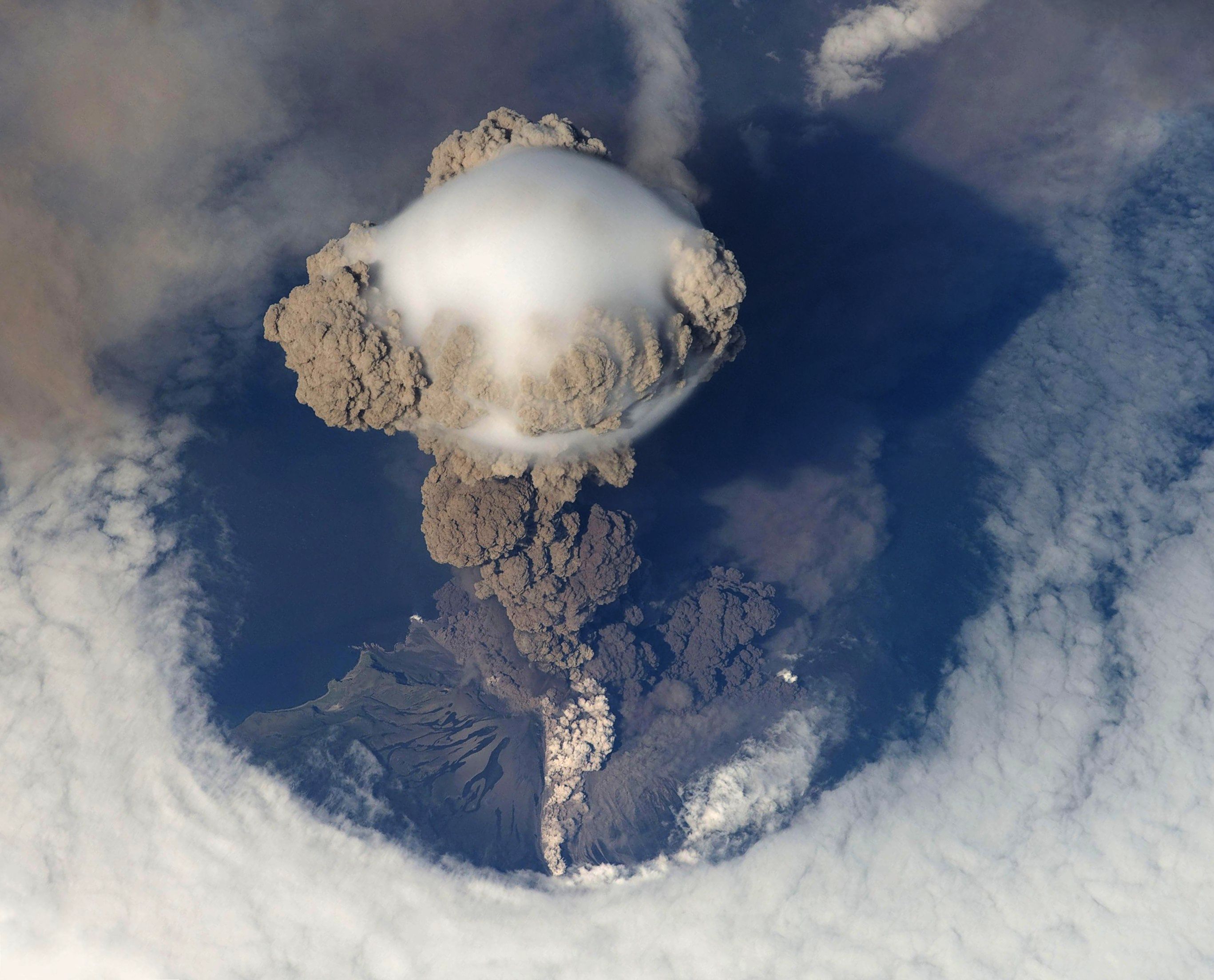
When the subducting plate, known as a slab, submerges into the depths of the mantle, the heat and pressure are so immense that lighter materials, known as volatiles, like water and carbon dioxide are pushed out of the subducting plate into an area called the mantle wedge above. The volatiles are released mostly via hydrated minerals that revert to non-hydrated forms in these conditions. These volatiles, when mixed with asthenospheric material above the tectonic plate, lower the melting point of the material. At the temperature of that depth, the material melts to form magma. This process of magma generation is called flux melting. Magma, because of its lower density, migrates toward the surface, creating volcanism. This forms a curved chain of volcanoes, due to many boundaries being curved on a spherical Earth, a feature called an arc. The overriding plate which contains the arc can be either oceanic or continental, where some features are different, but the general architecture remains the same.
How subduction initiates is still a matter of some debate. Presumably, this would start at passive margins where oceanic and continental crust meet. At the current time, there is oceanic lithosphere that is denser than the underlying asthenosphere on either side of the Atlantic Ocean that is not currently subducting. Why has it not turned into an active margin? Firstly, there is strength in the connection between the dense oceanic lithosphere and the less dense continental lithosphere it is connected to, which needs to be overcome. Gravity could cause the denser oceanic plate to force itself down, or the plate can start to flow ductility at a low angle. There is evidence that new subduction is starting off the coast of Portugal. Large earthquakes, like the 1755 Lisbon Earthquake, may even have something to do with this process of creating a subduction zone, though it is not definitive. Transform boundaries that have brought areas of different densities together are also thought to start subduction possibly.
Besides volcanism, subduction zones are also known for the largest earthquakes in the world. In places, the entire subducting slab can become stuck, and when the energy has built up too high, the entire subduction zone can slide at once along a zone extending for hundreds of kilometers along the trench, creating enormous earthquakes and tsunamis. The earthquakes can not only be large, but they can be deep, outlining the subducting slab as it descends. Subduction zones are the only places on Earth with fault surfaces large enough to create magnitude nine earthquakes. Also, because the faulting occurs beneath seawater, subduction also can create giant tsunamis, such as the 2004 Indian Ocean Earthquake and the 2011 Tōhoku Earthquake in Japan.
Subduction, which is a convergent motion, can have varying degrees of convergence. In places that have a high rate of convergence, mostly due to young, buoyant oceanic crust subducting, the subduction zone can create faulting behind the arc area itself, known as back-arc faulting. This faulting can be tensional, or this area is subject to compressional forces. A modern example of this occurs in the two ‘spines’ of the Andes Mountains. In the west, the mountains are formed from the volcanic arc itself; in the east, thrust faults have pushed up another, non-volcanic mountain range still part of the Andes. This type of thrusting can typically occur in two styles: thin-skinned, which only faults surficial rocks, and thick-skinned, which thrusts deeper crustal rocks. Oceanic-Continental Subduction
Oceanic-continental subduction occurs when an oceanic plate dives below continental plates. This boundary has a trench and mantle wedge, but the volcanoes are expressed in a feature known as a volcanic arc. A volcanic arc is a chain of mountain volcanoes, with famous examples including the Cascades of the Pacific Northwest (map) and the Andes of South America (map).

Oceanic-Oceanic Subduction
Oceanic-oceanic subduction zones have two significant differences from boundaries that have continental lithosphere. Firstly, each plate in an ocean-ocean plate boundary is capable of subduction. Therefore, it is typical that the denser, older, and colder of the two plates is the one that subducts. Secondly, since both plates are oceanic, volcanism creates volcanic islands instead of continental volcanic mountain ranges. This chain of active volcanoes is known as an island arc. There are many examples of this on Earth, including the Aleutian Islands off of Alaska (map), the Lesser Antilles in the Caribbean (map), and several island arcs in the western Pacific.

Continental-Continental Convergence
In places where two continental plates converge toward each other, subduction is not possible. This occurs where an ocean basin closes, and a passive margin is attempted to be driven down with the subducting slab. Instead of subducting beneath the continent, the two masses of continental lithosphere slam into each other in a process known as a collision. Collision zones are known for tall mountains and frequent, massive earthquakes, with little to no volcanism. With subduction ceasing with the collision, there is not a process to create the magma for volcanism.
Continental plates are too low density to subduct, which is why the process of collision occurs instead of subduction. Unlike the dense subducting slabs that form from oceanic plates, any attempt to subduct continental plates is short lived. An occasional exception to this is obduction, in which a part of a continental plate is caught beneath an oceanic plate, formed in collision zones or with small plates caught in subduction zones. This imbalance in density is solved by the continental material buoying upward, bringing oceanic floor and mantle material to the surface, and is the primary source of ophiolites. An ophiolite consists of rocks of the ocean floor that are moved onto the continent, which can also expose parts of the mantle on the surface.
Foreland basins can also develop near the mountain belt, as the lithosphere is depressed due to the mass of the mountains themselves. While subduction mountain ranges can cause this, collisions have many examples, with possibly the best modern example being the Persian Gulf, a feature only there due to the weight of the nearby Zagros Mountains. Collisions are powered by the subducting oceanic lithosphere, and eventually stop as the continental plates combine into a larger mass. In truth, a small portion of the continental crust can be driven down into the subduction zone, though due to its buoyancy, it returns to the surface over time. Because of the relative plastic nature of continental lithosphere, the zone of deformation is much broader. Instead of earthquakes located along a narrow boundary, collision earthquakes can be found hundreds of miles from the suture between the land masses.
The best modern example of this process occurs concurrently in many locations across the Eurasian continent and includes mountain building in the Pyrenees (the Iberian Peninsula converging with France, map), Alps (Italy converging into central Europe, map), Zagros (Arabia converging into Iran, map), and Himalayan (India converging into Asia, map) ranges. Eventually, as ocean basins close, continents join together to form a massive accumulation of continents called a supercontinent, a process that has taken place in hundreds of million-year cycles over earth’s history.
Divergent Boundaries
Divergent boundaries, sometimes called constructive boundaries, are places where two or more plates have a net movement away from each other. They can occur within a continental plate or an oceanic plate, though the typical pattern is for divergence to begin within continental lithosphere in a process known as “rift to drift,” described below.
Continental Rifting
Because of the thickness of continental plates, heat flow from the interior is suppressed. The shielding that supercontinents provide is even stronger, eventually causing upwelling of hot mantle material. This material uplift weakens overlying continental crust, and as convection beneath naturally starts pulling the material away from the area, the area starts to be deformed by tensional stress forming a valley feature known as a rift valley. These features are bounded by normal faults and include tall shoulders called horsts, and deep basins called grabens. When rifts form, they can eventually cause linear lakes, linear seas, and even oceans to form as divergent forces continue.

This breakup via rifting, while initially seeming random, actually has two influences that dictate the shape and location of rifting. First of all, the stable interiors of some continents, called a craton, are seemingly too strong to be broken apart by rifting. Where cratons are not a factor, rifting typically occurs along the patterns of a truncated icosahedron, or “soccer ball” pattern. This is the geometric pattern of fractures that requires the least amount of energy when expanding a sphere equally in all directions. Taking into account the radius of the Earth, this includes ~110 km segments of deformation and volcanism which have 120 degree turns, forming something known as failed rift arms. Even if the motion stops, a minor basin can develop in this weak spot called an aulacogen, which can form long-lived basins well after tectonic processes stop. These are places where extension started but did not continue. One famous example is the Mississippi Valley Embayment, which forms a depression through which the upper end of the Mississippi River flows. In places where the rift arms do not fail, for example, the Afar Triangle, three divergent boundaries can develop near each other forming a triple junction.

Rifts come in two types: narrow and broad. Narrow rifts contain concentrated stress or divergent action. The best active example is the East African Rift Zone, where the horn of Africa near Somalia is breaking away from mainland Africa (map). Lake Baikal in Russia is also an active rift (map). Broad rifts distribute the deformation over a wide area of many fault-bounded locations, like in the western United States in a region known as the Basin and Range (map). The Wasatch Fault, which created the Wasatch Range in Utah, marks the eastern edge of the Basin and Range (map).
Earthquakes, of course, do occur at rifts, though not at the severity and frequency of some other boundaries. Volcanism is also frequent in the extended, faulted, and thin lithosphere found at rift zones due to decompressional melting and faults acting as conduits for the lava reaching the surface. Many relatively young volcanoes dot the Basin and Range, and very strange volcanoes occur in East Africa like Ol Doinyo Lengai in Tanzania, which erupts carbonatite lavas, relatively cold liquid carbonate.
Mid-Oceanic Ridges
As rifting and volcanic activity progress, the continental lithosphere becomes more mafic and thinner, with the eventual result transforming the plate under the rifting area into the oceanic lithosphere. This is the process that gives birth to a new ocean, much like the narrow Red Sea (map) emerged with the movement of Arabia away from Africa. As the oceanic lithosphere continues to diverge, a mid-ocean ridge is formed.
A mid-ocean ridge, also known as a spreading center, has many distinctive features (map). They are the only places on Earth where the new oceanic lithosphere is being created, via slow oozing volcanism. As the oceanic lithosphere spreads apart, rising asthenosphere melts due to decreasing pressure and fills in the void, making the new lithosphere and crust. These volcanoes produce more lava than all the other volcanoes on Earth combined, and yet are not usually listed on maps of volcanoes due to the vast majority of mid-ocean ridges being underwater. Only rare locations, such as Iceland, are the volcanism and divergent characteristics seen on land. Technically, these places are not mid-ocean ridges, because they are above the surface of the seafloor. The video below is drone imagery of the Icelandic Lava River.
Alfred Wegener even hypothesized this concept of mid-ocean ridges. Because the lithosphere is very hot at the ridge, it has a lower density. This lower density allows it to isostatically ‘float’ higher on the asthenosphere. As the lithosphere moves away from the ridge by continued spreading, the plate cools and starts to sink isostatically lower, creating the surrounding abyssal plains with lower topography. Age patterns also match this idea, with younger rocks near the ridge and older rocks away from the ridge. Sediment patterns also thin toward the ridge, since the steady accumulation of dust and biologic material takes time to accumulate.
Mid-ocean ridges also are home to some of the unique ecosystems ever discovered, found around hydrothermal vents that circulate ocean water through the shallow oceanic crust and send it back out rich with chemical compounds and heat. While it was known for some time that hot fluids could be found on the ocean floor, it was only in 1977 when a team of scientists using the Diving Support Vehicle Alvin discovered a thriving community of organisms, including tube worms bigger than people. This group of organisms is not at all dependent on the sun and photosynthesis but instead relies on chemical reactions with sulfur compounds and heat from within the Earth, a process known as chemosynthesis. Before this discovery, the thought in biology was that the sun was the ultimate source of energy in ecosystems; now we know this to be false. Not only that, some have suggested it is from this that life could have started on Earth, and it now has become a target for extraterrestrial life (e.g., Jupiter’s moon Europa).
Transform Boundaries
A transform boundary, sometimes called a strike-slip or conservative boundary, is a place where the motion is of the plates sliding past each other. They can move in either dextral fashion with the side opposite moving toward the right or a sinistral fashion with the side opposite moving toward the left. Most transform boundaries can be viewed as a single fault or as a series of faults. As stress builds on adjacent plates attempting to slide them past each other, eventually a fault occurs and releases stress with an earthquake. Transform faults have a shearing motion and are common in places where tectonic stresses are transferred. In general, transform boundaries are known for only earthquakes, with little to no mountain building and volcanism.

The majority of transform boundaries are associated with mid-ocean ridges. As spreading centers progress, these aseismic fracture zone transform faults accommodate different amounts of spreading due to Eulerian geometry that a sphere rotates faster in the middle (Equator) than at the top (Poles) than along the ridge. However, the more significant transform faults, in the eyes of humanity, are the places where the motion occurs within continental plates with a shearing motion. These transform faults produce frequent moderate to large earthquakes. Famous examples include California’s San Andreas Fault (map), both the Northern and Eastern Anatolian Faults in Turkey (map), the Altyn Tagh Fault in central Asia (map), and the Alpine Fault in New Zealand (map).

3.13 Wilson Cycle
The Wilson Cycle, named for J. Tuzo Wilson who first described it in 1966, outlines the origin and subsequent breakup of supercontinents. This cycle has been operating for the last billion years with supercontinents Pangaea and Rodinia, and possibly billions of years before that. The driving force of this is two-fold. The more straightforward mechanism arises from the fact that continents hold the Earth’s internal heat much better than the ocean basins. When continents congregate together, they hold more heat in which more vigorous convection can occur, which can start the rifting process. Mantle plumes are inferred to be the legacy of this increased heat and may record the history of the start of rifting. The second mechanism for the Wilson Cycle involves the destruction of plates. While rifting eventually leads to drifting continents, a few unanswered questions emerge:
- Does their continued movement result from a continuation of the ridge spreading and underlying convection, known as ridge push?
- Do the tectonic plates move because of the weight of the subducting slab sinking via its density, known as slab pull?
- Alternatively, does the height of the ridge pushing down, known as gravitational sliding?
To be sure, these are all factors in plate movement and the Wilson Cycle. It does appear, in the current best hypothesis, that there is a more significant component of slab pull than ridge push. Plate tectonic models are beginning to detail the next supercontinent, called Pangea Proxima, that will form 250 million years.
3.14 Hotspots
While the Wilson Cycle can give a general overview of plate motions in the past, another process can give more precise, but mainly recent, plate movement. A hot spot (map) is an area of rising magma, causing a series of volcanic centers which form volcanic islands in the ocean or craters/mountains on land. There is not a plate tectonic process, like subduction or rifting, that causes this volcanic activity; it seems as if disconnected to plate tectonics processes. Also first postulated by J. Tuzo Wilson, in 1963, hot spots are places that have a continual source of magma with no earthquakes, besides those associated with volcanism. The classic idea is that hot spots do not move, though some evidence has been suggested that the hot spots do move as well. Even though hotspots and plate tectonics seem independent, there are some relationships between them, and they have two components: Firstly, there are several hot spots currently and several others in the past that are believed to have begun at the time of rifting. Secondly, as plate tectonics moves the plates around, the assumed stationary nature of hot spots creates a track of volcanism that can measure past plate movement. By using the age of the eruptions from hot spots and the direction of the chain of events, one can identify a specific rate and direction of movement of a plate over the time the hot spot was active.
Hot spots are still very mysterious in their exact mechanism of magma generation. The main camps on hotspot mechanics are opposed. Some claim deep sources of heat, from as deep as the core, bring heat up to the surface in a structure called a mantle plume. Some have argued that not all hot spots are sourced from deep within the planet, and are sourced from shallower parts of the mantle. Others have mentioned how difficult it has been to image these deep features. The idea of how hot spots start is also controversial. Usually, divergent boundaries are tabbed as the start, especially during supercontinent break up, though some question whether extensional or tectonic forces alone can explain the volcanism. Subducting slabs have also been named as a cause for hotspot volcanism. Even impacts of objects from space have been used to explain plumes. However they are formed, there are dozens found throughout the Earth. Famous examples include the Tahiti, Afar Triangle, Easter Island, Iceland, the Galapagos Islands, and Samoa. The United States has two of the largest and best-studied examples: Hawai’i and Yellowstone.
Hawaiian Hot Spot
The big island of Hawai’i (map) is the active end of the Hawaiian-Emperor seamount chain, which stretches across the Pacific for almost 6000 km. The evidence for this hot spot goes back at least 80 million years, and presumably, the hot spot was around before then, but rocks older than that in the Pacific Plate had already subducted. The most striking feature of the chain is a significant bend that occurs about halfway through the chain that occurred about 50 million years ago. The change in direction has been more often linked to a plate reconfiguration, but also to other things like plume migration. While it is often assumed that mantle plumes do not move, much like the plumes themselves, this idea is under dispute by some scientists.
Yellowstone Supervolcano
The Yellowstone Hot Spot (map) is formed from rising magma, much like Hawai’i. The big difference is Hawai’i sits on a thin oceanic plate, which makes the magma easily come to the surface. Yellowstone, however, is on a continental plate. The thickness of the plate causes the generally much more violent and less frequent eruptions that have carved a curved path in the western United States for over 15 million years (see figure). Some have speculated an even earlier start to the hotspot, tying it to the Columbia River flood basalts and even 70 million-year-old volcanism in Canada’s Yukon.
The most recent significant eruption formed the current caldera and the Lava Creek Tuff. This eruption threw into the atmosphere about 1000 cubic kilometers of magma erupted 631,000 years ago. Ash from the eruption has been found as far away as Mississippi. The next eruption, when it occurs, should be of similar size, causing a massive calamity to not only the western United States, but also the world. These so-called “supervolcanic” eruptions have the potential for volcanic winters lasting years. With so much gas and ash filling the atmosphere, sunlight is blocked and unable to reach Earth’s surface as well as usual, which could drastically alter global environments and send worldwide food production into a tailspin.
